The Watershed Reserve offers free access to more than 10 miles of hiking trails that are open from dawn to dusk throughout the year including a 0.7-mile, fully accessible raised boardwalk, a segment of the Lawrence-Hopewell Trail (LHT), and a 2,000-foot LHT-link trail made of porous asphalt that connects to our main driveway.
Our trails explore wetlands, forests, meadows, streams, an organic farm, and the four-acre Wargo Pond, which support the Watershed Reserve’s vibrant and diverse community of animals and plants. Some of the oldest trees in central New Jersey are found here, as well as fox, coyote, weasel, and flying squirrel. Birders will enjoy looking out for osprey, bobolink, Coopers hawk, red-shouldered hawk, or any of six species of owl that frequent the reserve.
Daily: Dawn to Dusk
Trails, Butterfly House (in season) & Pond
Weekdays: 9 a.m. – 5 p.m.
Sat. & Sun.: 10 a.m. – 4 p.m.
Most Holidays: 10 a.m. – 4p.m.
Please contact our events coordinator to make arrangements for large groups events@thewatershed.org
The trails are accessible from our main entrance at 31 Titus Mill Road, a parking lot on Moore’s Mill-Mount Rose Road and W. Broad Street just outside Hopewell Borough. View or download a copy of our trail map here:

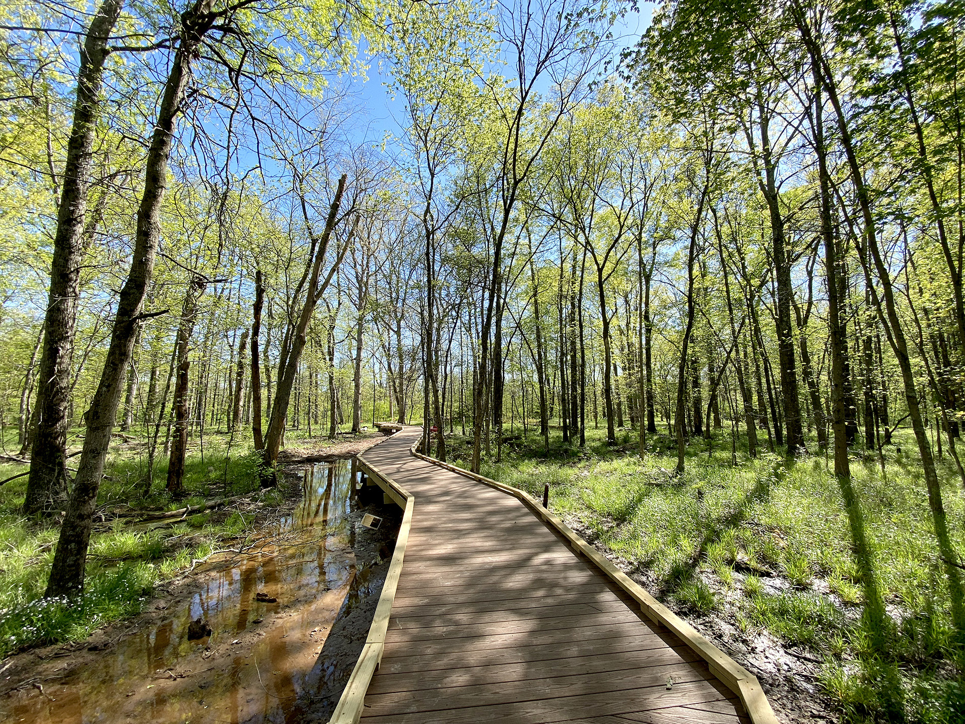
The fully accessible Hickory Loop Boardwalk is a raised walkway that spans 0.7 miles through scenic forests, meadows, and a stream. Named for the Shag bark hickory tree, with its silver-white bark hanging in loose strips, this raised path winds through hickory, maple, and oak trees.
Dedicated volunteers care for specific sections of land along the boardwalk through our Adopt-a-Plot program. Their efforts have led to the planting of hundreds of new native trees, a response to the devastating effects of the Emerald Ash Borer, a metallic green beetle from Northeast Asia, which destroyed many of the area’s ash trees.
Small plastic tubes protect the young trees, while some areas have deer enclosures enabling staff to study the impacts of the white-tailed deer. A small stream forms along the boardwalk during wet weather and flows into Stony Brook River. The entire area has been seeded with native groundcover species to prevent soil erosion. Hickory Loop is an example of accessibility, conservation, and research, benefiting visitors and the environment.
No off-trail travel is allowed to protect wildlife habitat.
Picnicking is allowed. Please carry out all trash.
Pets must be on leashes at all times. Respect other hikers by cleaning up after your pet.
No smoking or lighting of fires is allowed.
No hunting, trapping or collecting of any natural materials is allowed.
Catch and release fishing is permitted only from the dock and shores of Wargo Pond in conjunction with an appropriate license.
We want to ensure that you enjoy our ten miles of trails safely as possible. Here are a few safety tips.
Weather:
Please check local weather forecasts before heading out onto the trails. Be prepared with appropriate clothing and footwear for potentially muddy conditions. Here are a few potentially dangerous conditions to be aware of and how to stay safe:
Geocaching is a real-world, outdoor treasure hunt using GPS. It has been described as “hiking with a purpose”! Participants navigate to a specific set of geographic coordinates and then attempt to find the geocache, or special container, hidden at that location. All you need to get started is a GPS-enabled device – even your phone will work! Visit Geocaching.com to learn more about the activity and to locate caches placed all over the world.
The Watershed Reserve has several permanent geocaches hidden throughout our 950-acre property. It’s a great place to spend the day with a GPS, friends, and miles of trails through a variety of habitats. How do you know where to look? Enter these GPS coordinates into your device and start hunting! Just be sure to leave the treasure for the next geocacher.
| Name | Coordinates | GC Code |
| Watershed – Returning | N 40° 21.318 W 074° 46.543 | GC4HQCP |
| Watershed – Lonely Tree | N 40° 21.461′ W 074° 46.389′ | GC6N5MJ |
| Watershed – Hedging Your Bets | N 40° 21.168 W 074° 46.632 | GC3F2CG |
| Watershed – Cache but Don’t Dash | N 40° 20.969 W 074° 45.908 | GC6ZV2Y |
| Watershed – Bad Shot | N 40° 21.336′ W 074° 46.242′ | GC6MXMY |
| Watershed – Wilson Too | N 40° 21.624′ W 074° 46.074′ | GC6MXK8 |
| Watershed – Bush House | N 40° 22.825′ W 074° 46.372′ | GC6MQQW |
| Stony Brook – Four Seasons | N 40° 20.935 W 074° 46.656 | GC1F9G9 |
| Watershed – Pooped | N 40° 21.268 W 074° 46.105 | GC23J98 |
| In the Shadow of the Two Towers | N 40° 21.497 W 074° 46.011 | GC1KZ5F |
| Symplocarpus | N 40° 22.119 W 074° 46.468 | GC1M55V |
| Rocky Too | N 40° 22.662 W 074° 46.236 | GCH0R4 |
| Watershed – Wrong Turn | N 40° 21.122 W 074° 46.111 | GC45CNB |
Site by Scout Digital